Remote sensing has changed how we study the Earth. Remote sensing means collecting information from a distance, usually using satellites, aircraft, or drones. Instead of physically visiting a place, we can use satellite images to study cities, forests, farms, rivers, coastlines, and disaster-affected areas.
Today, high-resolution satellite images can show detailed views of the Earth’s surface. They can reveal roads, buildings, farms, trees, water bodies, and sometimes even vehicles. This makes them useful for urban planning, agriculture, environmental monitoring, disaster response, and national development.
When these images are combined with CNNs (Convolutional Neural Networks), they become even more powerful. A CNN is a type of artificial intelligence designed to understand images. It learns by detecting visual patterns such as edges, shapes, textures, colours, and object structures.
What Are High-Resolution Satellite Images?

High-resolution satellite images are detailed photographs of the Earth taken by satellites. The term high-resolution refers to how much detail the image contains. Satellite image resolution is usually measured using Ground Sample Distance, or GSD. GSD means the real-world ground area represented by one pixel. A pixelis the smallest square unit that makes up a digital image. For example, if an image has a resolution of 30 metres per pixel, each pixel represents a 30-metre by 30-metre area. This is useful for studying large areas, but it cannot clearly show small objects like houses or narrow roads. If an image has a resolution of 30 centimetres per pixel, each pixel represents a much smaller area. This allows the image to show rooftops, vehicles, tree canopies, small roads, and building shapes.
|
Resolution Type |
Ground Detail |
Example Use |
|
Very High Resolution |
Less than 0.5m per pixel |
Urban planning, building detection, detailed mapping |
|
High Resolution |
0.5m to 4m per pixel |
Agriculture monitoring, land cover mapping |
|
Medium Resolution |
4m to 30m per pixel |
Regional environmental monitoring |
For example, WorldView-3 provides very detailed commercial imagery, while Sentinel-2 provides free satellite images widely used for agriculture, environmental studies, and land monitoring.
Why Are Spectral Bands Important?
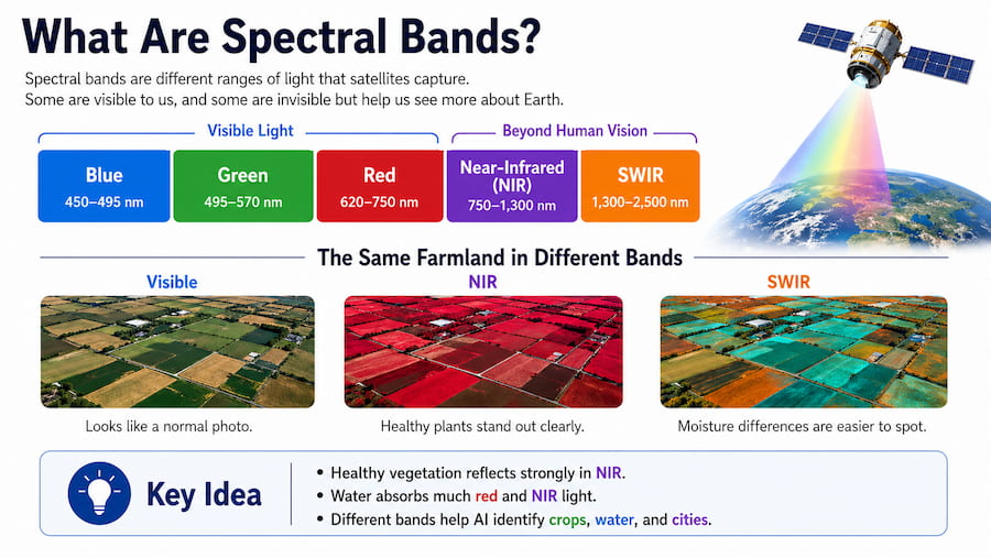
Satellite images do not only capture normal red, green, and blue colours like a phone camera. Many satellites also capture light that humans cannot see. These are called spectral bands. A spectral bandis a specific range of light recorded by a satellite sensor. Important bands include near-infraredand short-wave infrared. Near-infraredis useful for studying plants. Healthy vegetation reflects a lot of near-infrared light, while unhealthy vegetation reflects less. This helps detect plant stress before it is obvious to the human eye.
|
Surface Type |
Light Reflection Pattern |
|
Healthy vegetation |
Reflects strongly in near-infrared |
|
Water |
Absorbs much red and near-infrared light |
|
Concrete and asphalt |
Reflect differently from soil and vegetation |
|
Bare soil |
Has its own reflection pattern |
This is useful because some land types may look similar in normal images but appear different when viewed through extra spectral bands. CNNs can use these differences to classify land more accurately.
How Do CNNs Classify Satellite Images?
A CNN, or Convolutional Neural Network, is an AI model designed to analyse images.
A CNN does not “see” like a human. Instead, it reads an image as numbers. Each pixel has numerical values representing brightness, colour, or spectral information. The CNN studies these numbers and learns patterns from examples.
For satellite images, a CNN may learn that urban areas often have straight lines and sharp edges, forests have rough textures, and water bodies appear smoother in certain bands.
Step 1: Input Preprocessing
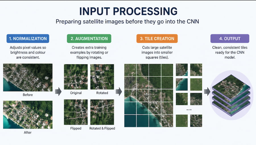
Before a satellite image is used by a CNN, it must be prepared. This is called preprocessing.
|
Preprocessing Step |
Simple Explanation |
|
Normalization |
Adjusts pixel values so brightness and colour are consistent |
|
Augmentation |
Creates extra training examples by rotating or flipping images |
|
Tile creation |
Cuts large satellite images into smaller squares |
Normalisation helps reduce confusion caused by lighting differences. For example, one image may look darker because of clouds, while another may look brighter because of sunlight.
Augmentation helps the CNN learn that objects can appear in different directions or conditions. A road is still a road whether it runs vertically, horizontally, or diagonally.
Tile creation is needed because satellite images are often too large to process at once. The image is divided into smaller tiles, such as 256×256 or 512×512 pixels.
Step 2: Convolutional Feature Extraction
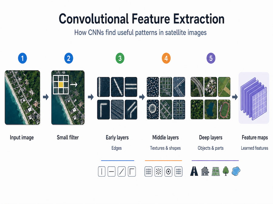
The main part of a CNN is the convolutional layer. A convolutional layer uses small filters that scan across an image. A filter is like a small window, often 3×3 or 5×5 pixels, that looks for specific patterns.
|
CNN Stage |
What It Learns |
|
Early layers |
Edges, lines, colour changes |
|
Middle layers |
Shapes, textures, object parts |
|
Deeper layers |
Roads, buildings, farms, forests, water bodies |
This layered process allows CNNs to recognise objects without humans manually programming every pattern.
Step 3: Pooling

CNNs often use pooling to reduce the amount of information being processed while keeping important details. A common type is max pooling, which keeps the strongest value from a small area of the image. This helps the CNN focus on key patterns instead of tiny position changes.For example, if a building appears slightly shifted in an image, pooling helps the CNN still recognise it as a building.
Step 4: Classification
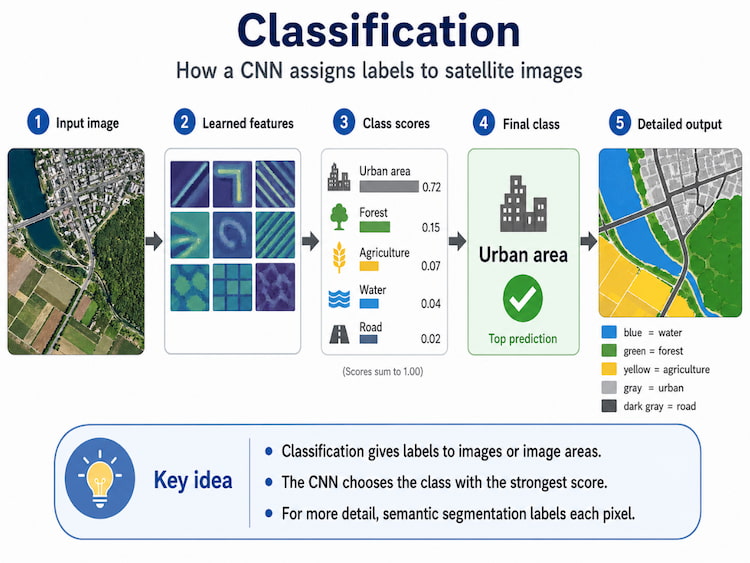
After extracting features, the CNN makes a prediction. It may classify an image or parts of an image into categories such as:
|
Possible Labels: |
|
|
|
|
|
|
|
|
Sometimes the CNN classifies an entire image tile. In more detailed tasks, it classifies every pixel. This is called semantic segmentation. Semantic segmentation is useful when exact boundaries matter, such as mapping floods, roads, rivers, buildings, or crop fields.
Common CNN Architectures Used for Satellite Images
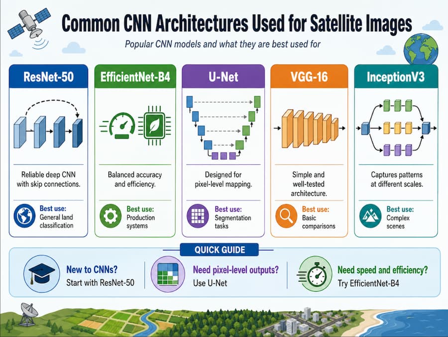
A CNN architecture is the design or structure of the CNN model. Different architectures suit different tasks.
|
Architecture | Explanation |
Best Use |
|
ResNet-50 |
Reliable CNN with shortcut connections |
General land classification |
|
EfficientNet-B4 |
Accurate and efficient |
Production systems |
|
U-Net |
Good at pixel-level mapping |
Segmentation tasks |
|
VGG-16 |
Simple and well-tested |
Basic comparisons |
|
InceptionV3 |
Captures patterns at different scales |
Complex scenes |
ResNet-50
ResNet stands for Residual Network. It uses skip connections, which allow information to skip certain layers and move forward more easily. This helps solve the vanishing gradient problem, where deep AI models struggle to learn because the learning signal becomes weaker as it moves through the network.
EfficientNet-B4
EfficientNet balances accuracy and efficiency. It performs well without using too much computing power, making it useful for processing large amounts of satellite data.
U-Net
U-Net is useful for segmentation, where every pixel needs to be labelled. It can show exactly which pixels are water, buildings, roads, or farmland. This makes it useful for flood mapping, crop boundary detection, land cover mapping, and urban planning.
How to Choose the Right CNN Architecture
The best CNN architecture depends on the project.
For beginners, ResNet-50 is a good starting point because it is widely used and well-documented.
For efficient production systems, EfficientNet-B4 is a strong option because it balances speed and accuracy.
For pixel-level mapping, U-Net is usually better because it produces detailed classification maps.
A useful method is transfer learning. Transfer learning means starting with a model that has already been trained on a large image dataset, then adjusting it for your specific satellite image task. This saves time and reduces the amount of training data needed.
Practical Uses of High-Resolution Satellite Images with CNNs
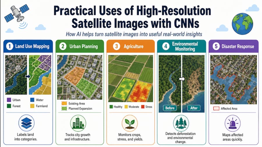
High-resolution satellite images and CNNs are used in many real-world areas.
|
Application |
What It Does |
Example |
|
Land use mapping |
Labels land into categories |
Urban, agriculture, forest, water |
|
Environmental monitoring |
Tracks changes in nature |
Deforestation, coastal erosion |
|
Agriculture |
Studies crops and farmland |
Crop health, yield prediction |
|
Disaster response |
Assesses damaged areas |
Flood mapping, storm damage |
|
Urban planning |
Studies city growth |
Roads, zoning, infrastructure |
Land Use Mapping and Urban Planning
Land use mapping identifies how different areas of land are being used. A CNN can classify satellite images into residential areas, commercial zones, industrial areas, farmland, forests, and water bodies.
This is useful for city planners because urban areas change quickly. In Bangkok, for example, development can spread into surrounding provinces and farmland. Satellite images help planners monitor where new buildings, roads, and infrastructure are appearing.
|
Use |
Explanation |
|
Urban sprawl detection |
Tracks how cities expand outward |
|
Zoning support |
Helps identify land use types |
|
Infrastructure planning |
Supports roads, utilities, and public facilities |
|
Farmland protection |
Shows where development may replace agriculture |
Environmental Monitoring
CNNs can monitor environmental changes over time. Satellite images allow large areas to be checked repeatedly, while CNNs can compare images and detect changes.
|
Environmental Use |
Explanation |
|
Deforestation detection |
Finds areas where forest has been removed |
|
Vegetation health monitoring |
Detects stressed plants |
|
Water body monitoring |
Tracks lakes, rivers, and reservoirs |
|
Coastal erosion tracking |
Measures shoreline changes |
This helps governments, researchers, environmental agencies, and businesses make better decisions.
Agriculture Applications
Agriculture is one of the most important uses of satellite CNN classification. High-resolution satellite images can identify crop types, measure crop health, estimate yields, and detect problems such as drought, pests, or poor irrigation. When combined with near-infrared bands, CNNs can detect vegetation health more accurately. Healthy crops usually reflect more near-infrared light, while stressed crops reflect less.
|
Agriculture Use |
Benefit |
|
Crop health monitoring |
Detects early signs of stress |
|
Yield estimation |
Predicts harvest output |
|
Irrigation management |
Identifies dry areas |
|
Pest detection |
Supports faster intervention |
|
Food security planning |
Helps track crop conditions |
Disaster Response and Damage Assessment

After floods, storms, landslides, earthquakes, or wildfires, response teams need accurate information quickly. Satellite images can cover large disaster areas faster than ground surveys. CNNs can process these images and classify damaged or affected areas. For example, after a flood, a CNN can identify which areas are covered by water. This helps emergency teams plan rescue support, food delivery, medical aid, or evacuation routes.
|
Disaster Use |
Explanation |
|
Flood mapping |
Shows which areas are flooded |
|
Building damage detection |
Identifies damaged structures |
|
Road blockage detection |
Helps plan emergency routes |
|
Wildfire mapping |
Shows burned areas |
|
Landslide monitoring |
Detects unstable land |
How High-Resolution Images Improve CNN Accuracy
High-resolution images help CNNs make better classifications because they provide more detail.
1. Better Feature Detection
A feature is a useful visual pattern in an image, such as an edge, shape, texture, colour, or object structure.
|
Feature |
Why It Matters |
|
Building outlines |
Helps identify urban areas |
|
Road shapes |
Helps map transport networks |
|
Tree canopies |
Helps classify vegetation |
|
Field patterns |
Helps identify agriculture |
|
Roof types |
Helps separate land use types |
Lower-resolution images may blur these details together, making classification harder.
2. Less Mixed-Pixel Confusion
A mixed pixel happens when one pixel contains more than one type of land cover.
For example, in a lower-resolution image, one pixel might include part of a building, road, and tree. The CNN must still give that pixel one label, which can cause errors.
High-resolution images reduce this problem because each pixel represents a smaller ground area.
3. Better Recognition of Subtle Patterns
Some land types look similar at low resolution but different at high resolution. For example, residential and commercial areas are both urban, but residential areas often have smaller and more regular buildings, while commercial areas may have larger buildings and parking lots.
|
Feature Type |
Low Resolution |
High Resolution |
|
Buildings |
Only large structures visible |
Individual buildings visible |
|
Roads |
Major roads only |
Streets, alleys, parking lots visible |
|
Vegetation |
General green areas |
Tree canopies and crop patterns visible |
|
Boundaries |
Less precise |
Sharper and more accurate |
Preparing Satellite Data for CNN Training
Before a CNN can classify satellite images well, the data must be prepared properly.
|
Stage |
Purpose |
|
Acquisition |
Collect satellite images |
|
Preprocessing |
Clean and correct the images |
|
Augmentation |
Create more training examples |
|
Splitting |
Divide data into training and testing sets |
|
Validation |
Check model performance |
Step 1: Acquire Satellite Images
The first step is collecting images from reliable sources.
|
Source |
Description |
|
USGS EarthExplorer |
Free Landsat and satellite data |
|
Sentinel Hub |
Access to Sentinel and other imagery |
|
Maxar/GBDX |
Commercial high-resolution imagery |
Important factors include cloud cover, image date, resolution, sensor type, and area of interest.
Step 2: Preprocess the Data
Raw satellite images usually need correction before CNN training.
Orthorectification corrects distortions caused by satellite angle, camera position, and terrain height. It helps objects appear in the correct map location.
Atmospheric correction reduces the effects of haze, dust, moisture, and sunlight conditions. This helps the image better represent the actual ground surface.
Clipping means cutting out only the area you want to study. This reduces file size and speeds up processing.
Step 3: Augment the Dataset
Data augmentation creates new versions of existing images to help the CNN learn better.
|
Augmentation Type |
Example |
|
Rotation |
Turning the image |
|
Flipping |
Mirroring the image |
|
Brightness adjustment |
Making it brighter or darker |
|
Contrast adjustment |
Changing visual difference |
|
Noise injection |
Adding small random changes |
This helps the CNN recognise objects under different conditions.
Step 4: Split the Dataset
The dataset should be divided into parts.
|
Dataset Part |
Purpose |
|
Training set |
Teaches the model |
|
Validation set |
Checks performance during training |
|
Test set |
Evaluates final performance |
A common split is 80% training and 20% validation. It is also important to make sure all classes are represented properly.
If one category appears much more often than another, the model may become biased. This is called class imbalance.
Step 5: Validate Model Performance
After training, the model must be tested.
|
Metric |
Meaning |
|
Accuracy |
Percentage of correct predictions |
|
IoU |
Measures overlap between predicted and actual areas |
|
Boundary F1-score |
Measures boundary accuracy |
IoU, or Intersection over Union, compares the predicted area with the actual labelled area. A higher IoU means the prediction matches the real area more closely.
Challenges in CNN Classification with Satellite Images
Although CNNs are powerful, satellite image classification has challenges.
|
Challenge |
Simple Explanation |
Possible Solution |
|
Spectral variability |
Same land type looks different in different conditions |
Normalization, histogram matching |
|
Computational demands |
Large images need strong computers |
Tiling, GPU processing |
|
Class imbalance |
Some categories appear much more often |
Weighted loss, focal loss |
|
Cloud occlusion |
Clouds block the ground |
Cloud masking, multi-date images |
|
Label scarcity |
Good labels are hard to create |
Transfer learning, expert review |
Spectral Variability
Spectral variability means the same surface may look different in different images.
For example, a rice field may look different during the rainy season, dry season, planting season, and harvest season. Sun angle, haze, and clouds can also affect the image.
Solutions include atmospheric correction, normalization, histogram matching, and using training images from different seasons.
Computational Demands
High-resolution satellite images are very large and can contain millions or billions of pixels. Processing them requires strong computing power.
A common solution is tiled processing, where a large image is cut into smaller tiles. Each tile is processed separately and later combined.
A GPU, or Graphics Processing Unit, is a computer chip that handles many calculations at once. It is much faster than a normal CPU for CNN training.
Class Imbalance
Class imbalance happens when some categories appear much more than others.
For example, if a dataset contains mostly urban and farmland images but very few water images, the CNN may become weaker at detecting water.
Solutions include weighted loss and focal loss.
A loss function tells the model how wrong its prediction is. Weighted loss gives more importance to rare classes, while focal loss focuses more on difficult examples.
Cloud Occlusion
Cloud occlusion happens when clouds block the ground in a satellite image.
This is a major issue in tropical countries like Thailand, especially during the monsoon season. Solutions include cloud masking, using images from multiple dates, and using SAR imagery. SAR, or Synthetic Aperture Radar, uses radar signals instead of normal light, allowing it to capture information through clouds and at night.
How AI Advisory Services Can Help
Some organizations may not have the expertise to build satellite CNN systems from scratch. AI advisory services can help plan, build, train, deploy, and maintain these systems.
|
Service |
Explanation |
|
Model fine-tuning |
Adapts a pretrained CNN to local data |
|
Workflow automation |
Automates image collection, processing, and output |
|
Agentic bot deployment |
Creates AI systems that monitor images and send alerts |
|
Training workshops |
Teaches internal teams how to use the tools |
|
Business integration |
Connects CNN results to dashboards or systems |
An agentic bot is an AI system that can carry out tasks more independently. For example, it can check new satellite images, classify land cover, detect changes, and send alerts when something important happens.
Real-World Uses in Thailand
Thailand is a strong example for satellite CNN applications because it has dense cities, large agricultural areas, forests, coastlines, and flood-prone regions.
Bangkok Urban Planning
CNN workflows can help study land cover across Bangkok and surrounding areas. A model can classify residential areas, commercial zones, industrial areas, roads, farmland, water bodies, and green spaces.
This helps planners track urban expansion, monitor land use changes, and reduce the time needed for manual mapping.
Agriculture Monitoring
CNN models can support agriculture monitoring in Thailand’s central plains, where rice farming and other crops are important.
A satellite CNN system can monitor crop areas, detect stress, and send alerts when problems appear.
|
Use |
Benefit |
|
Crop type classification |
Identifies different crops |
|
Crop stress detection |
Finds unhealthy crop areas |
|
Pest monitoring |
Supports early response |
|
Irrigation planning |
Finds areas needing water |
|
Yield prediction |
Estimates harvest output |
Future Trends in Satellite CNN Applications

Satellite CNN technology is still improving. Several trends are making it more accurate, faster, and easier to use.
CNN and Transformer Hybrid Models
A transformer is another type of AI model that is good at understanding relationships across large amounts of data.
CNNs are strong at detecting local patterns like edges and textures. Transformers are better at understanding wider context. Combining both can help models understand small details and larger scene patterns.
Edge Deployment
Edge deployment means running AI models on local devices instead of sending everything to the cloud.
This is useful when internet access is poor, data transfer is expensive, or fast decisions are needed. Smaller models can be created using model quantization, network pruning, and hardware optimization.
Multi-Modal Data Fusion
Multi-modal data fusion means combining different types of data.
For satellite imagery, this may involve combining optical images with SAR radar images. Optical images provide colour and spectral information, while SAR works through clouds and at night. Combining both can make classification more reliable.
AutoML
AutoML, or Automated Machine Learning, helps automate the process of choosing and improving AI models.
Instead of manually testing many CNN designs, AutoML tools can search for strong model settings automatically.
Agentic AI for Monitoring
Agentic AI systems can combine CNN classification with decision-making. For example, they can check new satellite images, preprocess them, classify land cover, compare results with older images, detect changes, and send alerts.
This is useful for flood monitoring, deforestation detection, crop updates, and infrastructure monitoring.
Conclusion
High-resolution satellite images and CNN classification make it possible to study the Earth in a faster, more detailed, and more automated way. Satellite images provide the visual data, while CNNs help interpret that data by recognising patterns and classifying land types.The key idea is simple: high-resolution satellite images show detailed views of the Earth, and CNNs help computers understand what those images contain.
This technology can support urban planning, agriculture, environmental monitoring, disaster response, and national development. In countries like Thailand, where cities are expanding, agriculture is important, forests need protection, and floods are a major concern, satellite CNN systems can provide valuable support.
Although challenges such as cloud cover, large data sizes, and limited training labels exist, they can be managed through preprocessing, transfer learning, tiled workflows, cloud masking, and AI-assisted monitoring systems. As CNNs, transformers, AutoML, edge computing, and agentic AI continue to improve, satellite image analysis will become more accurate, accessible, and useful for both technical and non-technical users.
Frequently Asked Questions
What are high-resolution satellite images?
High-resolution satellite images are detailed images of the Earth taken from satellites. Each pixel represents a small ground area, often less than one metre.
What is CNN?
A CNN, or Convolutional Neural Network, is an AI model designed to analyse images. It learns patterns such as edges, textures, shapes, and colours.
What does classification mean?
Classification means assigning labels to an image or parts of an image, such as forest, water, farmland, urban area, or road.
What is semantic segmentation?
Semantic segmentation is a detailed form of classification where every pixel is labelled. This is useful when exact boundaries are needed.
Why are spectral bands important?
Spectral bands allow satellites to capture more than normal visible colours. Bands such as near-infrared help detect vegetation health, water, soil, and urban materials.
What are the main challenges?
The main challenges include large file sizes, cloud cover, class imbalance, changing weather or seasonal conditions, and limited labelled training data.
How can businesses use this technology?
Businesses can use satellite CNN classification for agriculture monitoring, supply chain tracking, infrastructure planning, environmental risk assessment, real estate analysis, and disaster response.