Post-Processing in CNN Land Cover Classification: Challenges and Solutions
Introduction
Land cover classification is the process of identifying what type of surface exists in a particular area. This may include urban land, forests, water bodies, agricultural fields, bare soil, wetlands, or roads. It is widely used in environmental monitoring, urban planning, agriculture, disaster response, and land management.
Today, land cover classification is often done using CNNs, or Convolutional Neural Networks. CNNs are AI models designed to analyze images by detecting visual patterns such as edges, textures, colors, shapes, and spatial features. In satellite imagery, CNNs can help classify each part of an image into a land cover category.
However, raw CNN outputs are not always ready for real-world use. They may contain scattered incorrect pixels, broken regions, fuzzy boundaries, or missing rare land cover types. For example, a forest area may contain random pixels wrongly labeled as urban land, or a small pond may be ignored because water appears less frequently in the training data.
This is where post-processing becomes important.
Post-processing refers to the techniques applied after a CNN produces its prediction. These techniques clean up noisy outputs, smooth boundaries, connect fragmented regions, remove unrealistic pixels, and improve the final land cover map. In simple terms, CNNs provide the first prediction, while post-processing makes the result more accurate, readable, and useful.
For countries like Thailand, post-processing is especially important because satellite land cover analysis faces challenges such as monsoon cloud cover, fragmented paddy fields, rapid urban expansion, and mixed tropical landscapes.
Why Post-Processing Matters
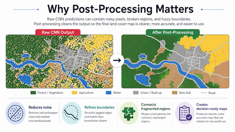
Raw CNN predictions can look technically correct but still be difficult to use. A land cover map may contain many small pixel-level errors that make the final output messy or unreliable.
For example:
- A rice field may be split into several tiny regions instead of one clear agricultural area.
- A river boundary may appear jagged or broken.
- A small water body may be removed or misclassified.
- Urban edges may blur into nearby vegetation.
- Cloud shadows may be mistaken for land cover changes.
Post-processing improves these issues by applying rules and image-processing techniques that make the map more spatially consistent.
The two main goals are:
- Noise reduction: removing scattered incorrect pixels.
- Boundary refinement: improving the edges between different land cover classes.
|
Technique |
Purpose |
Best Used For |
|
Median filtering |
Removes scattered pixel noise |
General cleanup of CNN outputs |
|
Gaussian smoothing |
Reduces random noise |
Smoother land cover maps |
|
Morphological operations |
Fixes shapes and small holes |
Irregular regions and fragmented areas |
|
CRF smoothing |
Improves spatial consistency |
Complex class boundaries |
|
Connected component analysis |
Groups and filters small regions |
Removing artifacts and merging fragments |
These methods help convert raw CNN predictions into cleaner land cover maps that decision-makers can trust.
Essential Post-Processing Techniques

1. Median Filtering
Median filtering is commonly used to remove “salt-and-pepper noise.” This type of noise appears as scattered pixels that are classified differently from their surrounding area.For example, if most pixels in an area are classified as forest, but a few random pixels are classified as urban land, median filtering can remove those isolated mistakes.
It works by replacing each pixel with the median, or middle value, of its neighboring pixels. A 3×3 kernel, which means a 3-pixel by 3-pixel window, is commonly used.Median filtering is useful because it removes small errors while preserving important boundaries better than simple averaging.
2. Gaussian Smoothing
Gaussian smoothing reduces random noise by averaging neighboring pixels. Pixels closer to the center of the filter are given more importance than pixels farther away. This creates smoother maps and reduces rough-looking outputs. However, it must be used carefully because too much smoothing can blur important details such as narrow roads, small rivers, or field boundaries. Gaussian smoothing is best used when the noise is spread across the image rather than appearing as isolated pixels.
3. Morphological Operations
Morphological operations are shape-based image-processing techniques. They are useful for correcting irregular land cover regions, removing small artifacts, and filling gaps.
|
Operation |
What It Does |
Example Use |
|
Erosion |
Shrinks a region |
Removes tiny noisy pixels |
|
Dilation |
Expands a region |
Fills small gaps |
|
Opening |
Erosion followed by dilation |
Removes small noise while keeping shape |
|
Closing |
Dilation followed by erosion |
Fills holes inside regions |
For example, if an agricultural field has small holes or broken sections in the prediction map, morphological closing can help fill those gaps. If there are tiny incorrect patches inside a larger region, morphological opening can help remove them.
These operations are especially useful for land cover classes that should appear as continuous areas, such as forests, fields, and water bodies.
4. Connected Component Analysis
Connected component analysis identifies separate regions made up of connected pixels with the same class label. This helps detect whether a predicted region is meaningful or just noise.
For example, if a CNN predicts a tiny 5-pixel urban patch in the middle of a forest, connected component analysis can identify it as a small isolated region. If it falls below a chosen size threshold, it can be removed.
This method is useful for cleaning fragmented predictions.
|
Step |
Purpose |
|
Identify connected regions |
Finds separate land cover patches |
|
Measure region size |
Checks whether each region is meaningful |
|
Remove tiny regions |
Deletes likely noise |
|
Merge nearby similar regions |
Creates more coherent maps |
However, the size threshold must be chosen carefully. If it is too strict, real small features such as ponds, narrow roads, or small farms may disappear.
5. Conditional Random Fields
A Conditional Random Field, or CRF, is an advanced post-processing method that improves spatial consistency. It considers not only the CNN’s prediction for each pixel but also the relationship between neighboring pixels.
A CNN may classify each pixel mainly based on what it sees in that pixel or nearby image features. A CRF adds context by asking:
- Are nearby pixels similar in color or texture?
- Are they close together?
- Should they likely belong to the same class?
- Is the boundary between these classes realistic?
CRF smoothing is especially useful for complex boundaries, such as where urban areas meet vegetation, or where agricultural fields are divided by roads and canals.
|
CRF Component |
Meaning |
|
Unary potentials |
The CNN’s confidence for each pixel |
|
Pairwise potentials |
The relationship between nearby pixels |
In simple terms, CRF helps the map look more realistic by reducing random label changes while still preserving important boundaries.
Common Challenges in CNN Land Cover Post-Processing
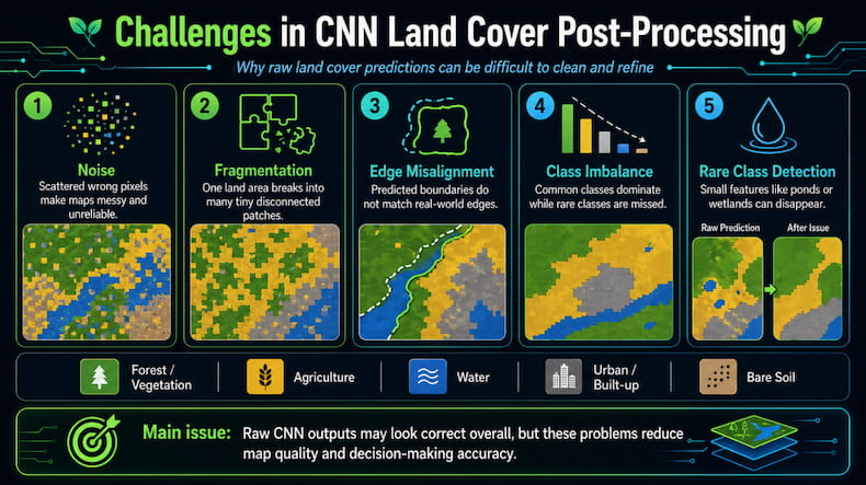
CNN land cover classification faces several common problems that post-processing tries to solve.
|
Challenge |
What It Means |
Why It Matters |
|
Noise |
Random incorrect pixels appear |
Makes maps messy and unreliable |
|
Fragmentation |
One land area is split into many pieces |
Reduces map readability |
|
Edge misalignment |
Boundaries do not match real-world edges |
Affects planning and analysis |
|
Class imbalance |
Some land types appear more often than others |
Rare classes may be missed |
|
Rare class detection |
Small or uncommon land types are underdetected |
Important features may disappear |
Class Imbalance
Class imbalance happens when some land cover types appear much more often than others. For example, if an image contains mostly agricultural land and urban areas, but only a small amount of water, the CNN may become better at detecting the common classes and worse at detecting water.
This is a problem because rare land cover types can still be important. Small water bodies, wetlands, mangroves, and narrow rivers may be small in area but highly important for environmental monitoring.
Post-processing can help by preserving small valid regions and reducing the model’s tendency to ignore rare classes.
Fragmentation
Fragmentation occurs when a single land cover area is broken into many small predicted pieces. This often happens in mixed landscapes where different land types are close together.
For example, in Thailand, agricultural landscapes often include small rice fields, roads, canals, houses, and patches of vegetation. A CNN may classify this area into many tiny fragments instead of producing clear, usable regions.
To fix this, methods such as connected component analysis, fragment merging, and morphological operations can be used.
Edge Misalignment
Edge misalignment happens when the predicted boundary does not match the actual boundary. This is common in satellite imagery because the resolution may not be high enough to capture fine details clearly. For example, the edge between an urban area and an agricultural field may appear blurry. This matters because accurate boundaries are important for urban planning, land-use monitoring, and environmental reporting.CRF smoothing, active contour methods, and morphological operations can help refine these boundaries.
Evaluating Post-Processing Effectiveness
Post-processing should not only make the map look cleaner. It should also improve accuracy. That is why evaluation metrics are needed.
|
Metric |
What It Measures |
Good Target |
|
IoU |
Overlap between predicted and actual regions |
Above 0.7 |
|
Boundary F1-score |
Accuracy of predicted boundaries |
Above 0.8 |
|
Hausdorff Distance |
Distance between predicted and actual boundaries |
Below 5 pixels |
|
Mean Accuracy |
Overall percentage of correct pixels |
Above 0.85 |
IoU
Intersection over Union, or IoU, measures how much the predicted region overlaps with the correct region. A higher IoU means the prediction matches the real land cover more closely.
Boundary F1-score
Boundary F1-score measures how accurately the model predicts boundaries. This is useful when the exact shape of land cover regions matters.
Hausdorff Distance
Hausdorff Distance measures the maximum distance between the predicted boundary and the true boundary. A lower value means the boundary alignment is better.
Mean Accuracy
Mean Accuracy measures the percentage of correctly classified pixels across the image. However, it should not be used alone because it may hide poor performance on rare classes.
Integrating Post-Processing into AI Workflows

For real-world use, post-processing should be integrated into an automated AI workflow. This allows large amounts of satellite imagery to be processed consistently and efficiently.
A typical workflow looks like this:
- Satellite images are collected.
- CNN model predicts land cover classes.
- Post-processing cleans the prediction.
- Evaluation metrics check the quality.
- The final map is exported for decision-making.
Tools such as Apache Airflow can automate the workflow by scheduling and managing each step. Docker can package the system so it runs consistently across different computers or cloud platforms. FastAPI can be used to create an interface where users upload satellite images and receive processed land cover results.
This kind of system is useful for government agencies, environmental consultants, agricultural companies, and urban planners that need to monitor land cover at scale.
Thailand-Specific Challenges in Land Cover Classification
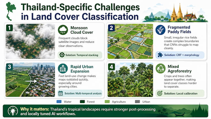
Thailand has several unique challenges that make post-processing especially important.
|
Challenge |
Impact |
Suitable Solution |
|
Monsoon cloud cover |
Blocks satellite images |
Temporal stacking |
|
Fragmented paddy fields |
Creates complex boundaries |
CRF and morphology |
|
Rapid urban expansion |
Land cover changes quickly |
Multi-temporal analysis |
|
Mixed agroforestry |
Crops and trees appear together |
Local calibration |
Monsoon Cloud Cover
During monsoon seasons, clouds can block large portions of satellite images. This makes classification harder because the CNN may not receive enough clear information.
One solution is temporal stacking, where images from different dates are combined. If one image is cloudy, another clearer image from a nearby date can help fill in missing information.
Fragmented Paddy Fields
Thailand’s agricultural areas often contain many small and irregular rice fields. These fields may be separated by canals, roads, houses, or vegetation.
This creates complex boundaries that CNNs may struggle with. Post-processing methods such as CRF smoothing and morphological operations can help reduce over-fragmentation while preserving field shapes.
Rapid Urban Expansion
Urban areas in Thailand, especially around Bangkok and provincial cities, can change quickly. Farmland may become housing, roads, factories, or commercial areas within a short period.
Because of this, land cover systems should use multi-temporal analysis, which compares satellite images across different dates to detect land cover changes more accurately.
Local Calibration
CNN models trained on foreign datasets may not perform well in Thailand because tropical landscapes look different from temperate regions.
Thai land cover includes rice paddies, rubber plantations, mangroves, cassava fields, sugarcane fields, mixed orchards, and urban-agricultural transition zones. These require local training data so the model can learn regional patterns.
Local calibration improves model accuracy and reduces classification errors.
AI Advisory for Custom CNN Post-Processing Pipelines
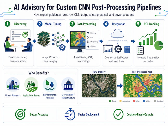
AI advisory services can help organizations design CNN post-processing pipelines that match their specific needs. This is important because different users may care about different outcomes.
For example:
- Urban planners may care most about building boundaries.
- Farmers may care about field-level accuracy.
- Environmental agencies may care about wetlands, forests, and water bodies.
- Infrastructure teams may care about roads and land-use changes.
A custom pipeline may include:
|
Service |
Purpose |
|
Client discovery |
Understand goals, land types, and accuracy needs |
|
Model finetuning |
Adapt CNNs to local satellite data |
|
Post-processing optimization |
Tune filters, CRF, and morphology settings |
|
Automation integration |
Connect the workflow to dashboards or APIs |
|
ROI tracking |
Measure time savings and accuracy improvements |
By combining CNN predictions with customized post-processing, organizations can produce maps that are not only technically accurate but also practical for decision-making.
From Model Finetuning to Deployed Land Cover Agents
A complete land cover monitoring system usually moves through three stages.
|
Phase |
Activity |
Output |
|
Model preparation |
Finetune CNN models such as U-Net |
Trained model |
|
Pipeline development |
Add post-processing and evaluation |
Reliable workflow |
|
Deployment |
Use APIs, dashboards, or AI agents |
Live monitoring system |
Model Preparation
A CNN model such as U-Net is often used for land cover classification because it performs pixel-level segmentation. This means it can classify each pixel in a satellite image and produce detailed land cover maps.
The model can be finetuned using local satellite images and ground truth labels.
Pipeline Development
After the model predicts land cover classes, post-processing methods such as CRF smoothing, median filtering, and morphological operations are applied. Evaluation metrics then check whether the output improved.
Deployment
The final system can be deployed through a dashboard, web API, or automated AI agent. This allows non-technical users to access land cover insights without manually running the model.
For example, a user may upload a satellite image and receive a cleaned land cover map showing urban areas, vegetation, water, and agriculture.
Conclusion
Post-processing is a critical step in CNN-based land cover classification. While CNNs can detect land cover patterns from satellite images, their raw outputs often contain noise, fragmented regions, blurry boundaries, and missed rare classes. Post-processing techniques such as median filtering, Gaussian smoothing, morphological operations, connected component analysis, and CRF smoothing help correct these issues.
For Thailand, post-processing is especially useful because of local challenges such as monsoon cloud cover, fragmented paddy fields, rapid urban expansion, and mixed tropical landscapes. These conditions make raw CNN predictions less reliable unless they are carefully cleaned and refined.
By combining CNN models with effective post-processing workflows, organizations can create clearer, more accurate, and more practical land cover maps. These maps can support agriculture, urban planning, environmental monitoring, and long-term land management. In short, post-processing turns AI predictions into decision-ready insights.
Frequently Asked Questions
What is post-processing in CNN land cover classification?
Post-processing refers to cleanup techniques applied after a CNN makes a prediction. It improves the final map by reducing noise, smoothing boundaries, removing tiny errors, and making regions more coherent.
Why are raw CNN predictions not enough?
Raw CNN outputs often contain scattered pixels, broken regions, blurry boundaries, and missed rare classes. These issues make the map harder to trust and use in real-world decision-making.
What is speckle noise?
Speckle noise refers to scattered incorrect pixels in a prediction map. For example, random water pixels may appear inside an urban area. Median filtering and morphological operations can help remove this.
How does CRF improve land cover maps?
CRF improves maps by considering the relationship between nearby pixels. It encourages similar neighboring pixels to have the same label while preserving important boundaries.
How can fragmented predictions be fixed?
Fragmented predictions can be fixed using connected component analysis, area thresholding, fragment merging, and morphological operations.
Why is Thailand challenging for land cover classification?
Thailand has monsoon cloud cover, small paddy fields, rapid urban growth, and complex tropical landscapes. These make satellite classification harder and increase the need for strong post-processing.
Why is computational efficiency important?
Satellite datasets can be very large. Efficient workflows are needed so land cover maps can be processed quickly. GPU acceleration, batch processing, lightweight filters, and automated pipelines can help.